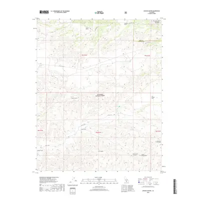
2018 Map of Apache Canyon
USGS Topo · Published 2018About this map
The San Andreas Fault cuts across the northeastern corner of this landscape, tracing the edge of the San Emigdio Mountains where they meet the high plateaus. Most of the territory falls within the Los Padres National Forest, a terrain of deep drainages and isolated meadows. Named settlements like Apache Potrero and Cowhead Potrero represent the characteristic "potreros" or mountain pastures common to this part of the Transverse Ranges. These flatlands are essential landmarks in a region dominated by rugged corridors such as Burges Canyon and Long Canyon. Water sources are critical points on the map, with Nettle Spring, Mystery Spring, and Blue Rock Spring providing vital resources in the arid backcountry. The road network, including Quatal Canyon Rd and Apache Cyn Rd, follows the natural contours of the canyons, linking the scattered potreros and seasonal camps.
Find a feature on this map
25 named features on this map. Tap any name to fly to it.
Don’t see what you’re looking for? This feature index may not catch every label — zoom into the map to look around manually.
Map Details
Editions of this 2018 Apache Canyon Map
This is the sole edition of this map. No revisions or reprints were ever made.
Other maps of this area

1903 · Mt. Pinos
USGS Topo · 1:125,000

1942 · Eagle Rest Peak
USGS Topo · 1:24,000

1942 · Ballinger Canyon
USGS Topo · 1:24,000

1943 · Rancho Nuevo Creek
USGS Topo · 1:24,000

1943 · Apache Canyon
USGS Topo · 1:24,000

1943 · San Guillermo
USGS Topo · 1:24,000

1943 · Sawmill Mountain
USGS Topo · 1:24,000

1943 · Santiago Creek
USGS Topo · 1:24,000
1943 · Ballinger Canyon
USGS Topo · 1:24,000

1943 · Cuyama Peak
USGS Topo · 1:24,000