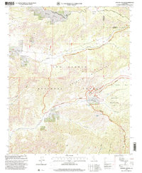
1995 Map of Apache Canyon
USGS Topo · Published 2000About this map
The Chumash Wilderness dominates the rugged interior of the Los Padres National Forest in this mid-1990s survey. The landscape is defined by the high elevations of the San Emigdio Mountains and a series of deep drainages including Apache Canyon, Quatal Canyon, and Long Canyon. A distinct social and industrial presence is noted at the Kern County Industrial Road Camp in the northern section, situated near the Apache Potrero. This map serves as a vital record of the wilderness boundary and the network of primitive four-wheel-drive tracks that traverse the high country. Resource management is evident through the placement of Water Tanks and protected water sources such as Blue Rock Spring and Mystery Spring. The transition from the San Emigdio Mesa into the canyon systems illustrates the complex topography of the Ventura and Kern County line.
Find a feature on this map
27 named features on this map. Tap any name to fly to it.
Don’t see what you’re looking for? This feature index may not catch every label — zoom into the map to look around manually.
Map Details
Editions of this 1995 Apache Canyon Map
This is the sole edition of this map. No revisions or reprints were ever made.
Other maps of this area

1903 · Mt. Pinos
USGS Topo · 1:125,000

1942 · Eagle Rest Peak
USGS Topo · 1:24,000

1942 · Ballinger Canyon
USGS Topo · 1:24,000

1943 · Rancho Nuevo Creek
USGS Topo · 1:24,000

1943 · Apache Canyon
USGS Topo · 1:24,000

1943 · San Guillermo
USGS Topo · 1:24,000

1943 · Sawmill Mountain
USGS Topo · 1:24,000

1943 · Santiago Creek
USGS Topo · 1:24,000
1943 · Ballinger Canyon
USGS Topo · 1:24,000

1943 · Cuyama Peak
USGS Topo · 1:24,000