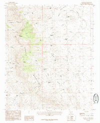
1985 Map of Apache Gap
USGS Topo · Published 1985About this map
The Caballo Mountains dominate this arid landscape, where steep canyons and high peaks define the topography of Sierra County. Surveyed for this provisional edition in the early 1980s, the terrain is marked by essential water management features such as Apache Gap Tank, Slater Red Tanks, and L 7 Red Tank, reflecting the critical need for water storage in this high-desert environment. The map details a network of 4WD trails providing access to remote summits like Timber Mountain and Brushy Mountain. Local industrial history is noted through scattered Prospects and a Prospect near Lone Mountain, indicating the area's mineral exploration. Geologic and hydrological patterns are visible in the winding courses of Palomas Gap Creek and the deep cuts of Bat Cave Canyon and Apache Gap Canyon.
Find a feature on this map
36 named features on this map. Tap any name to fly to it.
Don’t see what you’re looking for? This feature index may not catch every label — zoom into the map to look around manually.
Map Details
Editions of this 1985 Apache Gap Map
This is the sole edition of this map. No revisions or reprints were ever made.
Other maps of this area

1954 · Tularosa
USGS Topo · 1:250,000

1955 · Las Cruces
USGS Topo · 1:250,000

1958 · Las Cruces
USGS Topo · 1:250,000

1958 · Tularosa
USGS Topo · 1:250,000

1959 · Engle
USGS Topo · 1:62,500

1959 · Upham
USGS Topo · 1:62,500

1961 · Caballo
USGS Topo · 1:24,000

1961 · Williamsburg
USGS Topo · 1:24,000

1961 · Garfield
USGS Topo · 1:24,000

1979 · Truth or Consequences
USGS Topo · 1:100,000