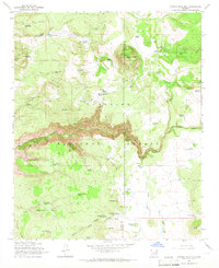
1965 Map of Apache Maid Mtn
USGS Topo · Published 1967About this map
The high country of the Coconino National Forest is defined here by its isolated ranching outposts and rugged volcanic topography. Centered around the prominent Apache Maid Mtn and its associated Lookout Tower, the landscape is a network of canyons and gulches adapted for livestock. Small settlements like Mullican Ranch and the Waldroup Place represent the human footprint in this part of Arizona during the mid-1960s. The land is heavily modified by numerous livestock tanks, such as Table Mtn Tank and Tin Roof Tank, which are essential for water management across the high plateaus. Travel through this area, including the crossing at Fivemile Pass, relied on a system of primitive jeep and pack trails, connecting remote sites like the Apache Maid Cabin and the T-Bar Ranch.
Find a feature on this map
70 named features on this map. Tap any name to fly to it.
Don’t see what you’re looking for? This feature index may not catch every label — zoom into the map to look around manually.
Map Details
Editions of this 1965 Apache Maid Mtn Map
3 editions found
Other maps of this area

1887 · Verde
USGS Topo · 1:250,000

1892 · Verde
USGS Topo · 1:250,000

1923 · Camp Verde
USGS Topo · 1:125,000

1932 · Camp Verde
USGS Topo · 1:125,000

1936 · Camp Verde
USGS Topo · 1:125,000

1954 · Holbrook
USGS Topo · 1:250,000

1957 · Holbrook
USGS Topo · 1:250,000

1958 · Holbrook
USGS Topo · 1:250,000

1960 · Holbrook
USGS Topo · 1:250,000
1965 · Calloway Butte
USGS Topo · 1:24,000