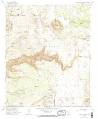
1965 Map of Apache Maid Mtn
USGS Topo · Published 1973About this map
Coconino National Forest defines this high-country landscape, where the rugged topography is dominated by the prominent peak of Apache Maid Mtn. The 1965 survey reveals a network of land management and early ranching history across the Yavapai and Coconino county line. Dozens of water tanks, such as Tin Roof Tank and Three Wall Tank, are scattered across the terrain to support livestock in an area otherwise drained by the deep incision of Wet Beaver Creek.
Find a feature on this map
66 named features on this map. Tap any name to fly to it.
Don’t see what you’re looking for? This feature index may not catch every label — zoom into the map to look around manually.
Map Details
Editions of this 1965 Apache Maid Mtn Map
3 editions found
Other maps of this area

1887 · Verde
USGS Topo · 1:250,000

1892 · Verde
USGS Topo · 1:250,000

1923 · Camp Verde
USGS Topo · 1:125,000

1932 · Camp Verde
USGS Topo · 1:125,000

1936 · Camp Verde
USGS Topo · 1:125,000

1954 · Holbrook
USGS Topo · 1:250,000

1957 · Holbrook
USGS Topo · 1:250,000

1958 · Holbrook
USGS Topo · 1:250,000

1960 · Holbrook
USGS Topo · 1:250,000
1965 · Calloway Butte
USGS Topo · 1:24,000