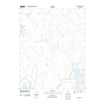
2010 Map of Apache Mesa
USGS Topo · Published 2010About this map
Apache Mesa and Horse Lake Mesa dominate this high-desert landscape in Rio Arriba County, defined by a complex network of seasonal drainages and significant water management structures. The eastern edge is anchored by the northern reaches of the El Vado Reservoir, while the western terrain features a string of upland water bodies including Stone Lake, Hayden Lake, and Stinking Lake. Human infrastructure is sparse, characterized by Stone Lake Dam and Hayden Lake Dam, which regulate these critical high-altitude water resources. The Pound Ranch serves as a lone named outpost of settlement in the southern sector, situated near the dramatic landform of La Puerta Grande. Movement through the area is primarily facilitated by Stone Lake Rd, connecting the scattered ranching interests and water features across this section of northern New Mexico.
Find a feature on this map
14 named features on this map. Tap any name to fly to it.
Don’t see what you’re looking for? This feature index may not catch every label — zoom into the map to look around manually.
Map Details
Editions of this 2010 Apache Mesa Map
This is the sole edition of this map. No revisions or reprints were ever made.
Other maps of this area

1954 · Aztec
USGS Topo · 1:250,000

1955 · Chama
USGS Topo · 1:62,500

1955 · Lumberton
USGS Topo · 1:62,500

1955 · Tierra Amarilla
USGS Topo · 1:62,500

1955 · Boulder Lake
USGS Topo · 1:62,500

1958 · Aztec
USGS Topo · 1:250,000

1962 · Aztec
USGS Topo · 1:250,000

1965 · Aztec
USGS Topo · 1:250,000

1981 · Chama
USGS Topo · 1:100,000
1983 · Pounds Mesa
USGS Topo · 1:24,000