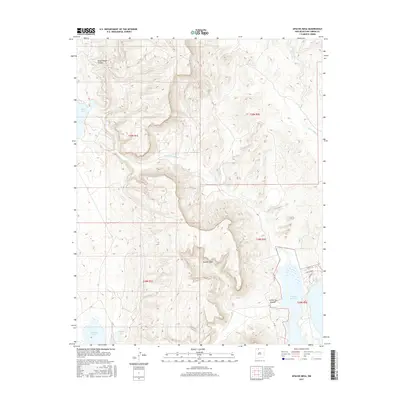
2017 Map of Apache Mesa
USGS Topo · Published 2017About this map
Apache Mesa dominates the central topography of this northern New Mexico landscape, serving as a high-ground divide between several significant water bodies. To the west, the arid basins of Stinking Lake, Stone Lake, and Hayden Lake reveal a complex drainage system, while the eastern edge of the quadrangle is defined by the expansive waters of the El Vado Reservoir. The map illustrates a transition from the deep relief of Pump House Canyon in the northwest to the more level reaches of La Puerta Grande. A sparse network of local roads, such as Co RD 322 and residential-style tracks like Pinon Ridge and Christy Ln, provides the primary access to these remote mesas and lakes, highlighting the region's low-density settlement pattern as of the mid-2010s.
Find a feature on this map
19 named features on this map. Tap any name to fly to it.
Don’t see what you’re looking for? This feature index may not catch every label — zoom into the map to look around manually.
Map Details
Editions of this 2017 Apache Mesa Map
This is the sole edition of this map. No revisions or reprints were ever made.
Other maps of this area

1954 · Aztec
USGS Topo · 1:250,000

1955 · Chama
USGS Topo · 1:62,500

1955 · Lumberton
USGS Topo · 1:62,500

1955 · Tierra Amarilla
USGS Topo · 1:62,500

1955 · Boulder Lake
USGS Topo · 1:62,500

1958 · Aztec
USGS Topo · 1:250,000

1962 · Aztec
USGS Topo · 1:250,000

1965 · Aztec
USGS Topo · 1:250,000

1981 · Chama
USGS Topo · 1:100,000
1983 · Pounds Mesa
USGS Topo · 1:24,000