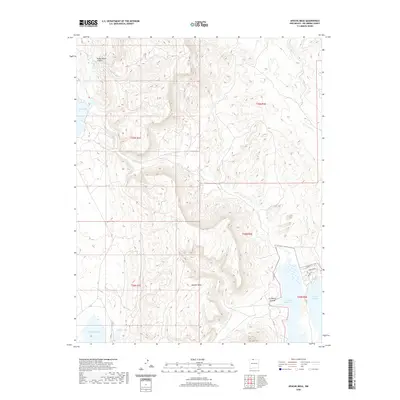
2020 Map of Apache Mesa
USGS Topo · Published 2020About this map
Apache Mesa dominates the central topography of this Rio Arriba County landscape, rising between the drainage of Boulder Cr and the eastern edge of the El Vado Reservoir. The southwestern corner of the sheet is characterized by a series of distinct basins, including Stinking Lake and Hayden Lake, while Stone Lake sits tucked into the western canyons. This 2020 survey documents the modern road network navigating the difficult terrain, including rural routes like Co RD 322 and named local passages such as Piñon Ridge and Juniper Ln near the reservoir. The map illustrates the sophisticated water management and natural drainage systems of northern New Mexico, from the depths of Pump House Canyon to the wide expanse of the reservoir near La Puerta Grande.
Find a feature on this map
22 named features on this map. Tap any name to fly to it.
Don’t see what you’re looking for? This feature index may not catch every label — zoom into the map to look around manually.
Map Details
Editions of this 2020 Apache Mesa Map
This is the sole edition of this map. No revisions or reprints were ever made.
Other maps of this area

1954 · Aztec
USGS Topo · 1:250,000

1955 · Chama
USGS Topo · 1:62,500

1955 · Lumberton
USGS Topo · 1:62,500

1955 · Tierra Amarilla
USGS Topo · 1:62,500

1955 · Boulder Lake
USGS Topo · 1:62,500

1958 · Aztec
USGS Topo · 1:250,000

1962 · Aztec
USGS Topo · 1:250,000

1965 · Aztec
USGS Topo · 1:250,000

1981 · Chama
USGS Topo · 1:100,000
1983 · Pounds Mesa
USGS Topo · 1:24,000