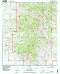
1996 Map of Apache Peak
USGS Topo · Published 2002About this map
Whetstone Mountains dominate this 1996 survey, where the high ridges of the Coronado National Forest meet the high desert floor. The map tracks a network of remote water sources essential for cattle ranching and survival, including named points like McNalley Tank, Ramsey Well, and Bathtub Spring. Significant elevation changes are marked by prominent summits such as Apache Peak, Granite Peak, and French Joe Peak, while the northern reaches include Lobo Pass and the Burro Gap. This area in Cochise and Pima counties is defined by its deep drainages, specifically Guindani Canyon and French Joe Canyon. Evidence of early and modern activity is scattered throughout, from a lone Quarry and various prospects to a localized Radio Facility and a series of rugged 4wd tracks and pack trails crossing the divide.
Find a feature on this map
65 named features on this map. Tap any name to fly to it.
Don’t see what you’re looking for? This feature index may not catch every label — zoom into the map to look around manually.
Map Details
Editions of this 1996 Apache Peak Map
This is the sole edition of this map. No revisions or reprints were ever made.
Other maps of this area

1904 · Patagonia
USGS Topo · 1:125,000

1905 · Patagonia
USGS Topo · 1:125,000

1915 · Benson
USGS Topo · 1:125,000

1926 · Whetstone
USGS Topo · 1:62,500

1932 · Elgin
USGS Topo · 1:62,500

1938 · Huachuca
USGS Topo · 1:62,500

1940 · Elgin
USGS Topo · 1:62,500

1943 · Benson
USGS Topo · 1:125,000

1947 · Elgin
USGS Topo · 1:62,500

1948 · Elgin
USGS Topo · 1:24,000