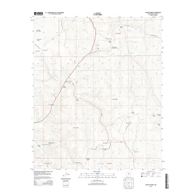
2013 Map of Apache Summit
USGS Topo · Published 2013About this map
Apache Summit sits at a high-elevation crossroads within the Sacramento Mountains, marked by a dense network of canyons and water-management features essential to the high desert ranching landscape. The terrain is deeply incised by drainages such as North Fork Tularosa Canyon and Cherokee Bill Canyon, while man-made improvements like Goat Windmill and numerous upland stock tanks including Pete Gaines Tank and Chatto Tank indicate the local reliance on groundwater. Evidence of communication and transport infrastructure is visible through names like West Telephone Canyon and various Indian Service routes. To the east, the elevation rises toward Harley Mtn, with the landscape transitioning into steep-walled corridors like Rock Canyon and Fence Canyon. The prevalence of family-named landmarks like Pete Gaines Canyon suggests a history of localized land use and homesteading in this Otero County region.
Find a feature on this map
49 named features on this map. Tap any name to fly to it.
Don’t see what you’re looking for? This feature index may not catch every label — zoom into the map to look around manually.
Map Details
Editions of this 2013 Apache Summit Map
This is the sole edition of this map. No revisions or reprints were ever made.
Other maps of this area

1950 · Sierra Blanca Peak
USGS Topo · 1:62,500

1950 · Mescalero
USGS Topo · 1:62,500

1955 · Roswell
USGS Topo · 1:250,000

1958 · Roswell
USGS Topo · 1:250,000

1962 · Roswell
USGS Topo · 1:250,000

1963 · Ruidoso Downs
USGS Topo · 1:24,000

1963 · Ruidoso
USGS Topo · 1:24,000

1963 · Firman Canyon
USGS Topo · 1:24,000

1963 · Apache Summit
USGS Topo · 1:24,000
1963 · Whitetail
USGS Topo · 1:24,000