
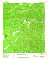
1950 Map of Mescalero
USGS Topo · Published 1955About this map
The Mescalero Apache Indian Reservation and Lincoln National Forest dominate this mid-century topographic record of the Sacramento Mountains. Life in the high desert is tied closely to the water courses, with settlements like Mescalero and Bent following the route of the Rio Tularosa. Cultural and historical landmarks are scattered throughout the canyon-cut terrain, notably the St Josephs Mission and the Mescalero Indian Cem. This era shows a landscape where industrial remnants like Blazers Mill and unidentified Ruins sit alongside active community centers such as the Bent Public Sch and Coronado Lodge. The mapping detail captures the complex drainage systems necessary for the region, including an Aqueduct and numerous isolated tanks like Soldier Tank and Danley Tank tucked into the steep-walled canyons.
Find a feature on this map
43 named features on this map. Tap any name to fly to it.
Don’t see what you’re looking for? This feature index may not catch every label — zoom into the map to look around manually.
Map Details
Editions of this 1950 Mescalero Map
2 editions found
Other maps of this area

1916 · Tularosa
USGS Topo · 1:125,000

1916 · Point Of Sands
USGS Topo · 1:125,000

1947 · Three Rivers
USGS Topo · 1:62,500

1948 · Tularosa
USGS Topo · 1:62,500

1948 · Holloman
USGS Topo · 1:62,500

1950 · Three Rivers
USGS Topo · 1:24,000

1950 · Alamogordo
USGS Topo · 1:62,500

1950 · Sierra Blanca Peak
USGS Topo · 1:62,500

1952 · Cloudcroft
USGS Topo · 1:62,500

1954 · Carlsbad
USGS Topo · 1:250,000