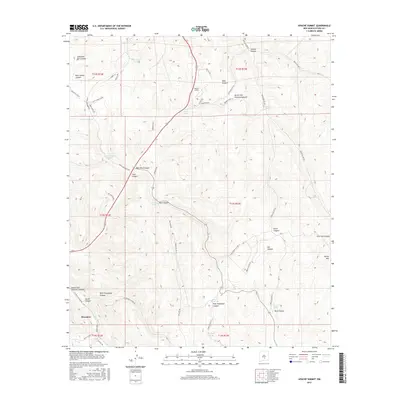
2017 Map of Apache Summit
USGS Topo · Published 2017About this map
Mescalero serves as a primary point of interest in this high-elevation New Mexico landscape, situated where the terrain transitions between steep canyon walls and forested peaks. The map reveals an intricate network of tribal and service roads, such as Indian Svc Rte 311 and Apache Blvd, which provide access to remote ranching and water infrastructure. Numerous catchments like Pete Gaines Tank and Rock Tank are vital markers in this arid environment, often found near the mouths of named drainages like Cherokee Bill Canyon and North Fork Tularosa Canyon. Notable landmarks such as Harley Mtn and the namesake Apache Summit anchor the topography. This survey provides local historians a detailed look at the water management and road system within the reservation, including the Goat Windmill and various telephone line corridors through East Telephone Canyon and West Telephone Canyon.
Find a feature on this map
63 named features on this map. Tap any name to fly to it.
Don’t see what you’re looking for? This feature index may not catch every label — zoom into the map to look around manually.
Map Details
Editions of this 2017 Apache Summit Map
This is the sole edition of this map. No revisions or reprints were ever made.
Other maps of this area

1950 · Sierra Blanca Peak
USGS Topo · 1:62,500

1950 · Mescalero
USGS Topo · 1:62,500

1955 · Roswell
USGS Topo · 1:250,000

1958 · Roswell
USGS Topo · 1:250,000

1962 · Roswell
USGS Topo · 1:250,000

1963 · Ruidoso Downs
USGS Topo · 1:24,000

1963 · Ruidoso
USGS Topo · 1:24,000

1963 · Firman Canyon
USGS Topo · 1:24,000

1963 · Apache Summit
USGS Topo · 1:24,000
1963 · Whitetail
USGS Topo · 1:24,000