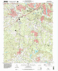
1993 Map of Apex
USGS Topo · Published 1999About this map
The town of Apex and its surroundings in western Wake County are captured during a period of significant suburban expansion in the early 1990s. The map delineates several distinct corporate boundaries, including the Apex Corp Bdy, Cary Corp Bdy, and Holly Springs Corp Bdy, illustrating how these municipalities were growing toward one another. Local landmarks such as the Baucom Sch and High Sch reflect the community's established infrastructure, while the residential layout of Piney Plains and several Trailer Parks shows the varied housing patterns of the era.
Find a feature on this map
49 named features on this map. Tap any name to fly to it.
Don’t see what you’re looking for? This feature index may not catch every label — zoom into the map to look around manually.
Map Details
Editions of this 1993 Apex Map
This is the sole edition of this map. No revisions or reprints were ever made.
Other maps of this area

1943 · Durham South
USGS Topo · 1:62,500

1943 · Raleigh
USGS Topo · 1:62,500

1951 · Raleigh
USGS Topo · 1:62,500

1951 · Durham South
USGS Topo · 1:62,500

1953 · Raleigh
USGS Topo · 1:250,000

1954 · Raleigh
USGS Topo · 1:250,000

1964 · Lake Wheeler
USGS Topo · 1:24,000

1964 · Angier
USGS Topo · 1:24,000

1964 · Garner
USGS Topo · 1:62,500

1968 · Raleigh West
USGS Topo · 1:24,000