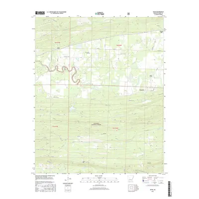
2017 Map of Aplin
USGS Topo · Published 2017About this map
Aplin and the winding Fourche La Fave River anchor this landscape in Perry County, where the river's serpentine course creates distinct natural landmarks like Lee Shoals and Busby Shoals. The topography is defined by the transition from rural valley settlements into the dense, elevated terrain of the Ouachita National Forest. Genealogists and local historians can locate the Pleasant Grove Cem near Aplin, while the small communities of Ragsdale and Cherry Hill sit further east along the valley floor. The map documents a rugged interior geography, featuring Link Mtn, Cedar Mtn, and Long Mtn rising above the headwaters of the Maumelle River and Big Huston Cr. This area serves as a significant recreational corridor, highlighted by the passage of the Ouachita National Recreation Trail through the southern timberlands.
Find a feature on this map
51 named features on this map. Tap any name to fly to it.
Don’t see what you’re looking for? This feature index may not catch every label — zoom into the map to look around manually.
Map Details
Editions of this 2017 Aplin Map
This is the sole edition of this map. No revisions or reprints were ever made.
Other maps of this area

1888 · Dardanelle #4
USGS Topo · 1:62,500

1889 · Morrilton No. 3
USGS Topo · 1:62,500

1890 · Benton
USGS Topo · 1:125,000

1890 · Hot Springs
USGS Topo · 1:125,000

1890 · Dardanelle
USGS Topo · 1:125,000

1892 · Morrillton
USGS Topo · 1:125,000

1894 · Morrillton
USGS Topo · 1:125,000

1894 · Hot Springs
USGS Topo · 1:125,000

1894 · Benton
USGS Topo · 1:125,000

1955 · Little Rock
USGS Topo · 1:250,000