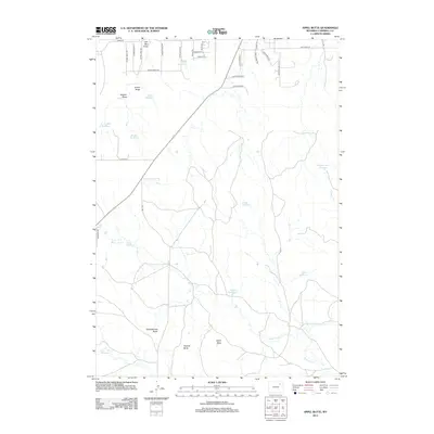
2012 Map of Appel Butte
USGS Topo · Published 2012About this map
Schoolhouse Butte and Appel Butte rise above a landscape defined by an extensive system of draws and water catchments in Campbell County. The drainage patterns of Bone Pile Cr and Bluegate Cr are punctuated by numerous small-scale water improvements, including Mankin Reservoir, Shaffer Reservoir, and Margaret Sarah Reservoir. These features reflect a ranching economy reliant on carefully managed runoff in an arid environment. The northern portion of the map shows a transition toward modern rural development with a network of local roads such as Stone Trail Ave and Antelope Valley St, contrasting with the more open terrain surrounding Sassick Butte to the south. The prevalence of family-named features like Janice Draw and Oluf Reservoir provides specific reference points for researchers looking into the mid-twentieth-century land management and regional geography of the Gillette area.
Find a feature on this map
41 named features on this map. Tap any name to fly to it.
Don’t see what you’re looking for? This feature index may not catch every label — zoom into the map to look around manually.
Map Details
Editions of this 2012 Appel Butte Map
This is the sole edition of this map. No revisions or reprints were ever made.
Other maps of this area

1954 · Gillette
USGS Topo · 1:250,000

1955 · Gillette
USGS Topo · 1:250,000

1958 · Gillette
USGS Topo · 1:250,000

1962 · Gillette
USGS Topo · 1:250,000

1971 · Scaper Reservoir
USGS Topo · 1:24,000

1971 · The Gap SW
USGS Topo · 1:24,000

1971 · Gillette East
USGS Topo · 1:24,000

1971 · Oriva
USGS Topo · 1:24,000
1971 · Pleasantdale
USGS Topo · 1:24,000
1971 · The Gap
USGS Topo · 1:24,000