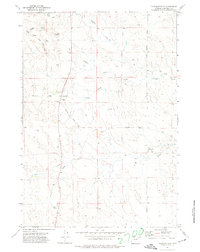
1971 Map of Pleasantdale
USGS Topo · Published 1974About this map
Pleasantdale serves as the focal point of this high-plains landscape in Campbell County, recorded just as modern infrastructure began to cross the drainage basins of the Powder River Country. The map reveals a sparsely settled ranching district centered on a Community Bldg and the Bundy Sch. Water, always the defining resource of the Wyoming basin, is managed through small-scale interventions like Vern Dam and the strategically located Butte Res along Dead Horse Creek. The terrain is characterized by broad prongs and draws, notably Caballo Creek and Hoe Creek, which dictate the winding paths of rural thoroughfares such as Clarkelen Road and Napier Road. Prominent landmarks like 21 Mile Butte and Hoe Spring provided essential navigational and survival points for early homesteaders and travelers navigating the breaks between the North and South Prongs of the local creek systems.
Find a feature on this map
21 named features on this map. Tap any name to fly to it.
Don’t see what you’re looking for? This feature index may not catch every label — zoom into the map to look around manually.
Map Details
Editions of this 1971 Pleasantdale Map
This is the sole edition of this map. No revisions or reprints were ever made.
Other maps of this area

1954 · Gillette
USGS Topo · 1:250,000

1955 · Newcastle
USGS Topo · 1:250,000

1955 · Gillette
USGS Topo · 1:250,000

1958 · Gillette
USGS Topo · 1:250,000

1958 · Newcastle
USGS Topo · 1:250,000

1959 · Savageton
USGS Topo · 1:62,500

1959 · North Star School
USGS Topo · 1:62,500

1962 · Gillette
USGS Topo · 1:250,000

1971 · Scaper Reservoir
USGS Topo · 1:24,000
1971 · Double Tanks
USGS Topo · 1:24,000