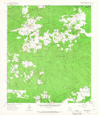
1963 Map of Apple Springs
USGS Topo · Published 1966About this map
Apple Springs and the surrounding woodlands of the Davy Crockett National Forest define this 1963 survey of eastern Trinity County. The landscape is a dense network of watercourses and small settlements, including the historically significant community of Nigton and the smaller outpost at Helmic. These small centers are connected by narrow roads that wind through the timberlands, interspersed with local landmarks like the Mt Zion Cem and the nearby Mt Zion Lookout.
Find a feature on this map
25 named features on this map. Tap any name to fly to it.
Don’t see what you’re looking for? This feature index may not catch every label — zoom into the map to look around manually.
Map Details
Editions of this 1963 Apple Springs Map
2 editions found
Other maps of this area

1949 · Keltys
USGS Topo · 1:24,000

1950 · Keltys
USGS Topo · 1:24,000

1950 · Centralia
USGS Topo · 1:24,000

1951 · Wells SW
USGS Topo · 1:24,000

1951 · Centralia
USGS Topo · 1:24,000

1953 · Palestine
USGS Topo · 1:250,000

1957 · Palestine
USGS Topo · 1:250,000

1963 · Crecy
USGS Topo · 1:24,000

1963 · Groveton East
USGS Topo · 1:24,000
1963 · Diboll
USGS Topo · 1:24,000