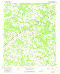
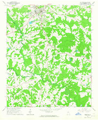
1964 Map of Apple Valley
USGS Topo · Published 1980About this map
The North Oconee River and its many tributaries, including Candler Creek and Gravelly Creek, define the landscape of Jackson County in the mid-1960s. This survey captures a rural landscape where small community centers like Maysville, Dry Pond, and Apple Valley are connected by a network of winding country roads and the Southern railway line. Local life is anchored by numerous rural congregations such as Hurricane Grove Ch and Oconee Ch, alongside family landmarks like the Bennett Cem and Riverside Cem. Cultural infrastructure of the era is evident in the presence of the County Airport and a nearby Drag Strip, contrasting with the institutional footprint of the County Prison further south. The map reflects a period of established agricultural settlement just before modern expansion began to alter the character of these small Georgia communities.
Find a feature on this map
32 named features on this map. Tap any name to fly to it.
Don’t see what you’re looking for? This feature index may not catch every label — zoom into the map to look around manually.
Map Details
Editions of this 1964 Apple Valley Map
2 editions found
Other maps of this area

1891 · Gainesville
USGS Topo · 1:125,000

1891 · Carnesville
USGS Topo · 1:125,000

1954 · Greenville
USGS Topo · 1:250,000

1958 · Greenville
USGS Topo · 1:250,000

1964 · Commerce
USGS Topo · 1:24,000

1964 · Maysville
USGS Topo · 1:24,000
1964 · Winder North
USGS Topo · 1:24,000
1964 · Nicholson
USGS Topo · 1:24,000

1964 · Pendergrass
USGS Topo · 1:24,000
1964 · Jefferson
USGS Topo · 1:24,000