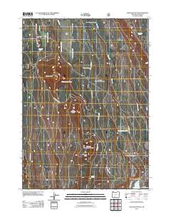
2011 Map of Applegate Butte
USGS Topo · Published 2011About this map
Ray Ranch sits near the northern edge of this high-elevation landscape, where the terrain is defined by a series of volcanic rises and seasonal water sources. The prominent Applegate Butte and Little Applegate Butte dominate the central portion of the quadrangle, while Crawford Butte anchors the southern reaches. This area in Klamath County is characterized by a sophisticated network of forest roads, including Nat For Dev Rd 4519 and Nat For Dev Rd 4530, which provide access to vital springs and waterholes in an otherwise arid environment. Local hydrography is sparse but critical, evidenced by the presence of Slabhouse Springs, Applegate Spring, and Beaverdam Springs at higher elevations. To the southeast, the terrain descends toward Hawks Lake and the Williamson River Rd, suggesting a landscape shaped by both geological history and the practical needs of regional forest management and ranching.
Find a feature on this map
21 named features on this map. Tap any name to fly to it.
Don’t see what you’re looking for? This feature index may not catch every label — zoom into the map to look around manually.
Map Details
Editions of this 2011 Applegate Butte Map
This is the sole edition of this map. No revisions or reprints were ever made.
Other maps of this area

1889 · Klamath
USGS Topo · 1:250,000

1894 · Klamath
USGS Topo · 1:250,000

1955 · Klamath Falls
USGS Topo · 1:250,000

1956 · Calimus Butte
USGS Topo · 1:62,500

1957 · Chiloquin
USGS Topo · 1:62,500

1957 · Klamath Marsh
USGS Topo · 1:62,500

1957 · Lenz
USGS Topo · 1:62,500

1958 · Klamath Falls
USGS Topo · 1:250,000

1980 · Williamson River
USGS Topo · 1:100,000
1988 · Chiloquin
USGS Topo · 1:24,000