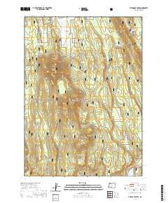
2020 Map of Applegate Butte
USGS Topo · Published 2020About this map
Winema National Forest encompasses this section of the Oregon Cascades, defined by a series of volcanic peaks and crucial water sources. Applegate Butte and Little Applegate Butte dominate the central landscape, while Crawford Butte rises further south. These landmarks provided essential navigational points for early travellers and forest managers. The availability of water is highlighted by several named sources, including Slabhouse Springs, Beaverdam Springs, and Applegate Spring. To the southeast, Hawks Lake sits near the Williamson River Road, which serves as a primary transit corridor through the timberland. Northward, the terrain opens into Wilson Flats and the high ground of Sand Point, showing the transition between dense forest and the open flats of the high plateau region.
Find a feature on this map
19 named features on this map. Tap any name to fly to it.
Don’t see what you’re looking for? This feature index may not catch every label — zoom into the map to look around manually.
Map Details
Editions of this 2020 Applegate Butte Map
This is the sole edition of this map. No revisions or reprints were ever made.
Other maps of this area

1889 · Klamath
USGS Topo · 1:250,000

1894 · Klamath
USGS Topo · 1:250,000

1955 · Klamath Falls
USGS Topo · 1:250,000

1956 · Calimus Butte
USGS Topo · 1:62,500

1957 · Chiloquin
USGS Topo · 1:62,500

1957 · Klamath Marsh
USGS Topo · 1:62,500

1957 · Lenz
USGS Topo · 1:62,500

1958 · Klamath Falls
USGS Topo · 1:250,000

1980 · Williamson River
USGS Topo · 1:100,000
1988 · Chiloquin
USGS Topo · 1:24,000