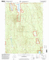
1998 Map of Applegate Butte
USGS Topo · Published 2000About this map
Applegate Butte dominates this section of the Winema National Forest, serving as a high-altitude vantage point with its summit Lookout and nearby Communication Tower. The landscape is a network of volcanic landforms and high-desert water sources, where the drainage of Hog Creek and the expanse of Wilson Flat indicate the seasonal movement of water across the terrain. Smaller peaks like Little Applegate Butte and Crawford Butte punctuate the forest, while numerous water sources such as Slabhouse Springs, Applegate Spring, and Miranda Spring provided critical infrastructure for forest management and local ranching. A long Pipeline and a Gravel Pit in the southwest corner reflect the industrial footprint of resource management and road maintenance within these public lands at the close of the twentieth century.
Find a feature on this map
16 named features on this map. Tap any name to fly to it.
Don’t see what you’re looking for? This feature index may not catch every label — zoom into the map to look around manually.
Map Details
Editions of this 1998 Applegate Butte Map
This is the sole edition of this map. No revisions or reprints were ever made.
Other maps of this area

1889 · Klamath
USGS Topo · 1:250,000

1894 · Klamath
USGS Topo · 1:250,000

1955 · Klamath Falls
USGS Topo · 1:250,000

1956 · Calimus Butte
USGS Topo · 1:62,500

1957 · Chiloquin
USGS Topo · 1:62,500

1957 · Klamath Marsh
USGS Topo · 1:62,500

1957 · Lenz
USGS Topo · 1:62,500

1958 · Klamath Falls
USGS Topo · 1:250,000

1980 · Williamson River
USGS Topo · 1:100,000
1988 · Chiloquin
USGS Topo · 1:24,000