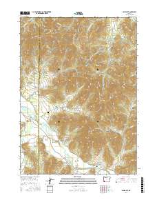
2017 Map of Applegate
USGS Topo · Published 2017About this map
Provolt and Applegate anchor the valley floor where the Applegate River winds through the borderlands of Josephine and Jackson counties. This 2017 survey shows a landscape defined by sharp elevation changes, where alluvial flats like Missouri Flat sit in the shadow of peaks such as Billy Mtn and Old Blue Mtn. The region’s history of settlement and agriculture is visible in the legacy of water management, evidenced by the Watts and Topping Ditch and Cook Reservoir. Along Williams Hwy, researchers can find the Missouri Flat Cem, a vital site for local genealogical study. The map is heavily marked by gulches named for early families and geography, including Schoolhouse Gulch, Packers Gulch, and Myrtle Gulch, reflecting a terrain shaped by both natural drainage and human industry.
Find a feature on this map
76 named features on this map. Tap any name to fly to it.
Don’t see what you’re looking for? This feature index may not catch every label — zoom into the map to look around manually.
Map Details
Editions of this 2017 Applegate Map
This is the sole edition of this map. No revisions or reprints were ever made.
Other maps of this area

1908 · Grants Pass
USGS Topo · 1:125,000

1954 · Oregon Caves
USGS Topo · 1:62,500

1954 · Gold Hill
USGS Topo · 1:62,500

1954 · Grants Pass
USGS Topo · 1:62,500

1954 · Ruch
USGS Topo · 1:62,500

1955 · Medford
USGS Topo · 1:250,000

1957 · Medford
USGS Topo · 1:250,000

1958 · Medford
USGS Topo · 1:250,000
1974 · Grants Pass NE
USGS Topo · 1:24,000
1983 · Mt. Isabelle
USGS Topo · 1:24,000