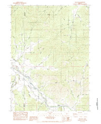
1983 Map of Applegate
USGS Topo · Published 1983About this map
The Applegate River and its intricate network of agricultural irrigation ditches define the landscape of this southwestern Oregon valley during the early 1980s. A complex system of water management is visible through the winding paths of the Laurel Hill Ditch, Watts and Topping Ditch, and Berryman Ditch, which support the lowlands of Missouri Flat. These structures highlight the region's reliance on river water for both agriculture and mining operations.
Find a feature on this map
46 named features on this map. Tap any name to fly to it.
Don’t see what you’re looking for? This feature index may not catch every label — zoom into the map to look around manually.
Map Details
Editions of this 1983 Applegate Map
This is the sole edition of this map. No revisions or reprints were ever made.
Other maps of this area

1908 · Grants Pass
USGS Topo · 1:125,000

1954 · Oregon Caves
USGS Topo · 1:62,500

1954 · Gold Hill
USGS Topo · 1:62,500

1954 · Grants Pass
USGS Topo · 1:62,500

1954 · Ruch
USGS Topo · 1:62,500

1955 · Medford
USGS Topo · 1:250,000

1957 · Medford
USGS Topo · 1:250,000

1958 · Medford
USGS Topo · 1:250,000
1974 · Grants Pass NE
USGS Topo · 1:24,000
1983 · Mt. Isabelle
USGS Topo · 1:24,000