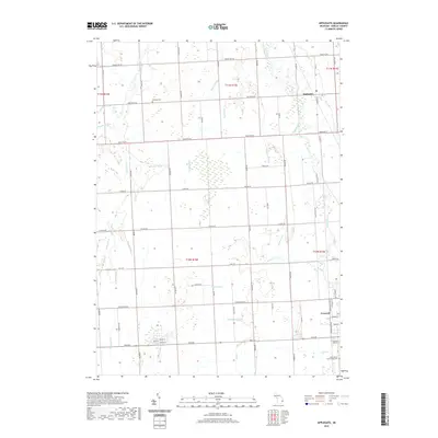
2019 Map of Applegate
USGS Topo · Published 2019About this map
Black River and its numerous tributaries, including Arnot Cr and Mills Cr, carve a complex drainage system through this Sanilac County landscape. The village of Applegate sits in the northeastern corner, while the more developed city of Croswell occupies the southeast, characterized by a structured grid of streets including N Black River Rd and Sanborn St. This area is defined by its agricultural heritage and civil organization, with the landscape divided into clear sections by arterial roads like Marlette Rd and Applegate Rd. Local history is anchored by several burial grounds, such as Steckley Cem and the extensive Saint Patrick Mount Hope Cem. The prevalence of named water features, from Elk Creek to engineered channels like Roskey Drain and McClelland Drain, highlights the historic importance of water management to the region's land use.
Find a feature on this map
58 named features on this map. Tap any name to fly to it.
Don’t see what you’re looking for? This feature index may not catch every label — zoom into the map to look around manually.
Map Details
Editions of this 2019 Applegate Map
This is the sole edition of this map. No revisions or reprints were ever made.
Other maps of this area

1954 · Flint
USGS Topo · 1:250,000

1958 · Flint
USGS Topo · 1:250,000

1961 · Roseburg
USGS Topo · 1:24,000
1961 · Jeddo
USGS Topo · 1:24,000

1961 · Yale
USGS Topo · 1:24,000

1963 · Sandusky
USGS Topo · 1:24,000

1963 · Peck
USGS Topo · 1:24,000

1963 · Croswell
USGS Topo · 1:24,000

1963 · Port Sanilac
USGS Topo · 1:24,000

1963 · Applegate
USGS Topo · 1:24,000