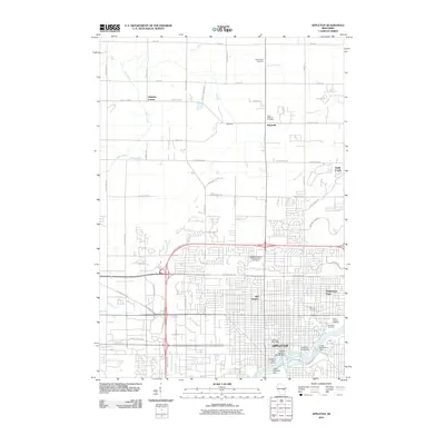
2010 Map of Appleton
USGS Topo · Published 2010About this map
The Fox River anchors the urban core of Appleton as it appeared in the early 21st century, revealing the industrial and educational infrastructure that has long defined this Wisconsin city. Significant landmarks like Lawrence University and the Appleton Water Works sit near the river's edge, alongside the Middle Appleton WP-309 Dam and Lower Appleton Dam. To the north, the landscape shifts from dense city blocks to outlying residential areas and agricultural intersections, including Mackville and Hamples Corner. The map records numerous community spaces, from the large Riverside Cemetery near the river to the Appleton Highland Memorial Park Cemetery further inland. Residential developments like Bell Heights and Whispering Pines show the expansion of the metropolitan area toward the north and east, where the namesake Apple Creek flows through the landscape.
Find a feature on this map
60 named features on this map. Tap any name to fly to it.
Don’t see what you’re looking for? This feature index may not catch every label — zoom into the map to look around manually.
Map Details
Editions of this 2010 Appleton Map
This is the sole edition of this map. No revisions or reprints were ever made.
Other maps of this area

1911 · Neenah
USGS Topo · 1:62,500

1955 · Neenah
USGS Topo · 1:62,500

1955 · Appleton
USGS Topo · 1:24,000

1955 · Appleton
USGS Topo · 1:62,500

1955 · Neenah
USGS Topo · 1:24,000

1955 · Green Bay
USGS Topo · 1:250,000

1956 · New London
USGS Topo · 1:48,000

1961 · Oshkosh
USGS Topo · 1:62,500

1961 · Oshkosh NE
USGS Topo · 1:24,000
1969 · Greenville
USGS Topo · 1:24,000