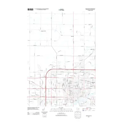
2013 Map of Appleton
USGS Topo · Published 2013About this map
The Fox River corridor anchors this modern study of Outagamie County, showing the northern reaches of a growing city at the start of the 2010s. The dense residential and commercial grid of northern Appleton transitions into agricultural land and smaller named communities, providing a clear view of the urban-rural interface. Notable municipal infrastructure, such as the Appleton Water Works, sits along the river, while the outskirts are marked by long-standing landmarks like Schabo's Hillside Orchard and small settlements including Mackville and Hamples Corner. The map tracks the drainage patterns of Bear Creek and Mud Creek as they weave through developing neighborhoods like Whispering Pines and Bell Heights. This era of documentation is particularly useful for observing how modern road networks, including State Road 47 and County Highway A, have shaped the expansion of these Fox Cities communities.
Find a feature on this map
203 named features on this map. Tap any name to fly to it.
Don’t see what you’re looking for? This feature index may not catch every label — zoom into the map to look around manually.
Map Details
Editions of this 2013 Appleton Map
This is the sole edition of this map. No revisions or reprints were ever made.
Other maps of this area

1911 · Neenah
USGS Topo · 1:62,500

1955 · Neenah
USGS Topo · 1:62,500

1955 · Appleton
USGS Topo · 1:24,000

1955 · Appleton
USGS Topo · 1:62,500

1955 · Neenah
USGS Topo · 1:24,000

1955 · Green Bay
USGS Topo · 1:250,000

1956 · New London
USGS Topo · 1:48,000

1961 · Oshkosh
USGS Topo · 1:62,500

1961 · Oshkosh NE
USGS Topo · 1:24,000
1969 · Greenville
USGS Topo · 1:24,000