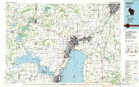
1984 Map of Appleton
USGS Topo · Published 1985About this map
The Fox River corridor serves as the industrial and urban backbone of this mid-1980s landscape, connecting a dense chain of communities including Appleton, Neenah, Menasha, and Kaukauna. This planimetric study highlights the region's complex water network, where the expansive Lake Winnebago meets the river system alongside Lake Poygan and Lake Butte des Morts. The infrastructure reflects a heavy reliance on both rail and road, with the Chicago and North Western and Soo Line railroads threading through the manufacturing centers that grew up around the river's water power.
Find a feature on this map
204 named features on this map. Tap any name to fly to it.
Don’t see what you’re looking for? This feature index may not catch every label — zoom into the map to look around manually.
Map Details
Editions of this 1984 Appleton Map
2 editions found
Other maps of this area

1910 · Fond du Lac
USGS Topo · 1:62,500

1911 · Neenah
USGS Topo · 1:62,500

1915 · Neshkoro
USGS Topo · 1:48,000

1916 · Ripon
USGS Topo · 1:48,000

1918 · Neshkoro
USGS Topo · 1:62,500

1918 · Ripon
USGS Topo · 1:62,500

1954 · De Pere
USGS Topo · 1:62,500

1954 · School Hill
USGS Topo · 1:24,000

1954 · Green Bay West
USGS Topo · 1:24,000

1954 · Denmark
USGS Topo · 1:62,500