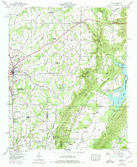
1948 Map of Arab
USGS Topo · Published 1975About this map
Arab and the surrounding plateau of the Tennessee Valley are captured here during a period of post-war growth along U.S. 231. The landscape is defined by the high Divide separating the waters of Shoal Creek and Warrior Creek, where small agricultural communities like Scant City and Friendship are interspersed with country institutions such as Grassy Sch and Rocky Mount Church.
Find a feature on this map
60 named features on this map. Tap any name to fly to it.
Don’t see what you’re looking for? This feature index may not catch every label — zoom into the map to look around manually.
Map Details
Editions of this 1948 Arab Map
3 editions found
Other maps of this area

1885 · Gadsden
USGS Topo · 1:125,000

1888 · Cullman
USGS Topo · 1:125,000

1888 · Gadsden
USGS Topo · 1:125,000

1892 · Cullman
USGS Topo · 1:125,000

1892 · Gadsden
USGS Topo · 1:125,000

1895 · Gadsden
USGS Topo · 1:125,000

1903 · Gadsden
USGS Topo · 1:125,000

1936 · Guntersville
USGS Topo · 1:24,000

1936 · Guntersville Dam
USGS Topo · 1:24,000

1936 · Hulaco
USGS Topo · 1:24,000