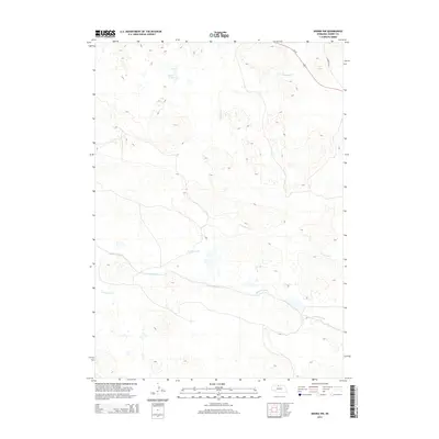
2014 Map of Arabia NW
USGS Topo · Published 2014About this map
Swan Lake sits amidst the complex topography of north-central Nebraska, where water management and historic transportation routes define the landscape. The Ainsworth Canal cuts across the southern portion of this area, illustrating the critical infrastructure used to move water through the Sandhills region. This map documents a transition in the use of transit corridors, specifically highlighting the Cowboy Trl, a recreational trail established on the former right-of-way of the Chicago and North Western Railway. The convergence of natural drainage systems like Fairfield Cr and Evergreen Cr alongside engineered waterways and the modern Us-20 corridor provides a clear picture of how land use and resource management have shaped this part of Cherry County.
Find a feature on this map
6 named features on this map. Tap any name to fly to it.
Don’t see what you’re looking for? This feature index may not catch every label — zoom into the map to look around manually.
Map Details
Editions of this 2014 Arabia NW Map
This is the sole edition of this map. No revisions or reprints were ever made.
Other maps of this area

1950 · Sparks
USGS Topo · 1:62,500

1950 · Simeon
USGS Topo · 1:62,500

1950 · Arabia
USGS Topo · 1:62,500

1950 · Valentine
USGS Topo · 1:62,500

1957 · Valentine
USGS Topo · 1:250,000

1959 · Valentine
USGS Topo · 1:250,000

1983 · Valentine South
USGS Topo · 1:24,000
1983 · Thatcher
USGS Topo · 1:24,000
1983 · Sparks SE
USGS Topo · 1:24,000
1985 · Arabia SE
USGS Topo · 1:24,000