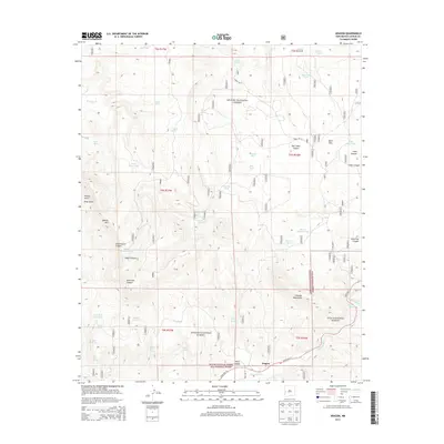
2013 Map of Aragon
USGS Topo · Published 2013About this map
Aragon sits along the southern edge of this West New Mexico landscape, positioned where State Hwy 12 follows the path of the Tularosa River. The terrain is defined by the overlap of the Apache National Forest and the Gila National Forest, creating a high-altitude environment characterized by numerous seasonal water sources and canyons. Water management for ranching or wildlife is evident through a network of named tanks, including Horse Pasture Tank, Negrito Tank, and Castillo Tank. Significant landmarks such as Apache Mtn and the Tularosa Mountains dominate the local topography. This 2013 survey illustrates the complex drainage systems that feed into the valley, with named draws like Schoolhouse Canyon, Negro Canyon, and Red Steer Canyon carving through the mountain slopes. The presence of numerous springs, such as Negrito Springs, Oronio Spring, and Mata Spring, highlights the critical importance of groundwater in this arid forest region.
Find a feature on this map
87 named features on this map. Tap any name to fly to it.
Don’t see what you’re looking for? This feature index may not catch every label — zoom into the map to look around manually.
Map Details
Editions of this 2013 Aragon Map
This is the sole edition of this map. No revisions or reprints were ever made.
Other maps of this area

1915 · Reserve
USGS Topo · 1:125,000

1918 · Pelona
USGS Topo · 1:125,000

1918 · Reserve
USGS Topo · 1:125,000

1954 · Clifton
USGS Topo · 1:250,000

1954 · Saint Johns
USGS Topo · 1:250,000

1957 · Clifton
USGS Topo · 1:250,000

1957 · Saint Johns
USGS Topo · 1:250,000

1958 · Clifton
USGS Topo · 1:250,000

1958 · Saint Johns
USGS Topo · 1:250,000

1962 · Clifton
USGS Topo · 1:250,000