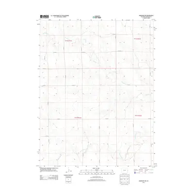
2013 Map of Arapahoe NW
USGS Topo · Published 2013About this map
The Smoky Hill River winds through the southern portion of this Cheyenne County landscape, defining the local drainage patterns alongside Big Timber Cr. This 2013 survey captures the high plains of Eastern Colorado, where the terrain is organized by a precise grid of county roads that facilitate ranching and transit. Primary corridors like Co Road 50 and Co Road 55 provide the framework for movement between sections, while intersecting routes such as Co Road Z and Co Road BB delineate the vast agricultural and open lands of the region. The map illustrates the sparsely populated but highly structured nature of the modern plains, showing how watercourses and a rigid road network dictate the utility of the land.
Find a feature on this map
19 named features on this map. Tap any name to fly to it.
Don’t see what you’re looking for? This feature index may not catch every label — zoom into the map to look around manually.
Map Details
Editions of this 2013 Arapahoe NW Map
This is the sole edition of this map. No revisions or reprints were ever made.
Other maps of this area

1892 · Cheyenne Wells
USGS Topo · 1:125,000

1894 · Cheyenne Wells
USGS Topo · 1:125,000

1954 · Limon
USGS Topo · 1:250,000

1954 · Lamar
USGS Topo · 1:250,000

1957 · Limon
USGS Topo · 1:250,000

1958 · Limon
USGS Topo · 1:250,000

1958 · Lamar
USGS Topo · 1:250,000

1969 · Arapahoe SE
USGS Topo · 1:24,000
1969 · Arapahoe NE
USGS Topo · 1:24,000

1969 · Mount Sunflower SW
USGS Topo · 1:24,000