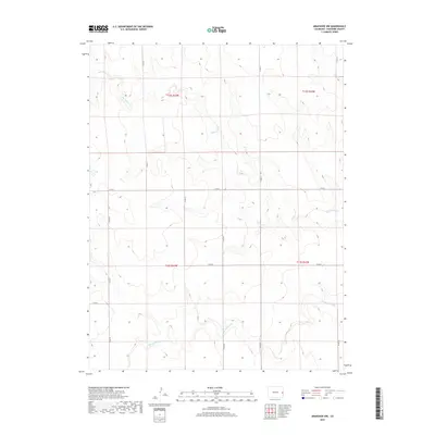
2019 Map of Arapahoe NW
USGS Topo · Published 2019About this map
The Smoky Hill River flows through the southern section of this Cheyenne County landscape, a vital watercourse in the High Plains of eastern Colorado. This 2019 survey by the U.S. Geological Survey details a sparsely populated ranching and agricultural region defined by a rigid section-line road network. The map reveals the local geography through arterial routes like Co Rd 50 and Co Rd Z, which navigate the subtle drainage basins of northern tributaries such as Big Timber Cr. The layout of these roads reflects the enduring influence of the Public Land Survey System, which remains the primary organizing principle for property and transit across these plains. Genealogists and land researchers can use these precise grid coordinates to locate historical family plots or original homesteads within the townships of T12S and T13S.
Find a feature on this map
15 named features on this map. Tap any name to fly to it.
Don’t see what you’re looking for? This feature index may not catch every label — zoom into the map to look around manually.
Map Details
Editions of this 2019 Arapahoe NW Map
This is the sole edition of this map. No revisions or reprints were ever made.
Other maps of this area

1892 · Cheyenne Wells
USGS Topo · 1:125,000

1894 · Cheyenne Wells
USGS Topo · 1:125,000

1954 · Limon
USGS Topo · 1:250,000

1954 · Lamar
USGS Topo · 1:250,000

1957 · Limon
USGS Topo · 1:250,000

1958 · Limon
USGS Topo · 1:250,000

1958 · Lamar
USGS Topo · 1:250,000

1969 · Arapahoe SE
USGS Topo · 1:24,000
1969 · Arapahoe NE
USGS Topo · 1:24,000

1969 · Mount Sunflower SW
USGS Topo · 1:24,000