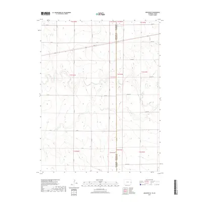
2019 Map of Arapahoe SE
USGS Topo · Published 2019About this map
The High Plains landscape where Colorado and Kansas meet is defined here by the winding course of Ladder Creek. This modern survey reveals a highly organized grid of range and township lines, including Township 13 South Range 42 West and Township 14 South Range 43 West, which partition the dry terrain for agricultural and ranching use. While many rural areas in this region are punctuated by dense development, this map shows a sparse settlement pattern dominated by long-distance county roads and section-line trails. Names like Larkspur Road and Jackrabbit Road reflect local flora and fauna, while the boundary between Cheyenne and Wallace Counties bisects the northern half of the sheet. The prevalence of ephemeral ponds and the drainage of Ladder Creek illustrate the critical role of surface water management in this arid portion of the High Plains.
Find a feature on this map
32 named features on this map. Tap any name to fly to it.
Don’t see what you’re looking for? This feature index may not catch every label — zoom into the map to look around manually.
Map Details
Editions of this 2019 Arapahoe SE Map
This is the sole edition of this map. No revisions or reprints were ever made.
Other maps of this area

1892 · Cheyenne Wells
USGS Topo · 1:125,000

1894 · Cheyenne Wells
USGS Topo · 1:125,000

1954 · Lamar
USGS Topo · 1:250,000

1955 · Scott City
USGS Topo · 1:250,000

1958 · Lamar
USGS Topo · 1:250,000

1958 · Scott City
USGS Topo · 1:250,000

1959 · Weskan
USGS Topo · 1:62,500

1968 · Sharon Springs 3 NW
USGS Topo · 1:24,000

1969 · Arapahoe SE
USGS Topo · 1:24,000

1969 · Cheyenne Wells 4 NE
USGS Topo · 1:24,000