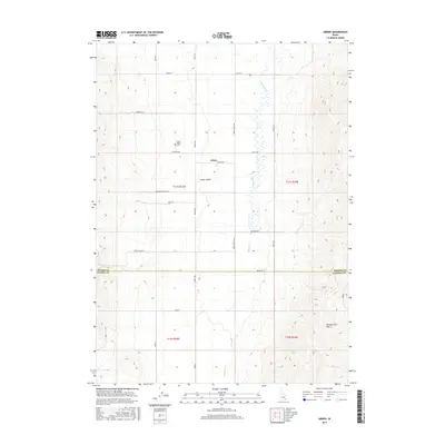
2017 Map of Arbon
USGS Topo · Published 2017About this map
Arbon Valley serves as the central landscape of this Idaho quadrangle, where the small community of Arbon is situated along Church Rd. The map illustrates a high-desert agricultural and ranching district organized around the seasonal waters of Bannock Cr, which flows northward through the valley floor. To the southeast, the terrain rises into the Pleasantview Hills, creating a stark contrast to the flat basin where most human activity is concentrated. Local history and genealogy interests are anchored by the Arbon Valley Cem, located just west of Bailey Rd. The township and range lines of T11S R33E and T11S R34E define the legal boundaries of the property, while the border between Power County and Oneida County cuts across the southern portion of the sheet near Phelps Rd. Numerous family-named routes, such as Roderick Ln and Andersen Rd, trace the settlement patterns of this rural Idaho interior.
Find a feature on this map
27 named features on this map. Tap any name to fly to it.
Don’t see what you’re looking for? This feature index may not catch every label — zoom into the map to look around manually.
Map Details
Editions of this 2017 Arbon Map
This is the sole edition of this map. No revisions or reprints were ever made.
Other maps of this area

1938 · Pauline
USGS Topo · 1:48,000

1944 · Arbon
USGS Topo · 1:62,500

1954 · Pocatello
USGS Topo · 1:250,000

1958 · Pocatello
USGS Topo · 1:250,000

1963 · Daniels
USGS Topo · 1:24,000

1968 · Daniels
USGS Topo · 1:24,000

1968 · Dairy Creek
USGS Topo · 1:24,000

1968 · Bradley Mtn
USGS Topo · 1:24,000

1971 · Bannock Peak
USGS Topo · 1:24,000
1971 · Pauline
USGS Topo · 1:24,000