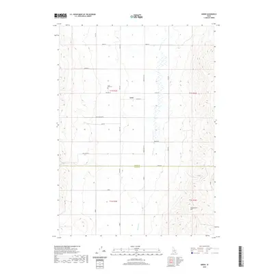
2020 Map of Arbon
USGS Topo · Published 2020About this map
Arbon centers this rural landscape in southeastern Idaho, where the high-elevation basin of the Bannock Cr valley is framed by the rising slopes of the Pleasantview Hills. The map documents a sparse, agricultural settlement pattern defined by a grid of named section roads and lanes, many of which carry the names of local families such as Bailey Rd, Andersen Rd, and Roderick Ln. The local community is anchored by the Arbon Valley Cem and landmarks like Church Rd, suggesting a long-standing ranching or farming history. Running north-south across the quadrangle, the drainage of Bannock Cr creates a distinct corridor of wetlands and varying terrain, while the southern portion of the map captures the transition across the Power Co Oneida Co line into the neighboring county.
Find a feature on this map
27 named features on this map. Tap any name to fly to it.
Don’t see what you’re looking for? This feature index may not catch every label — zoom into the map to look around manually.
Map Details
Editions of this 2020 Arbon Map
This is the sole edition of this map. No revisions or reprints were ever made.
Other maps of this area

1938 · Pauline
USGS Topo · 1:48,000

1944 · Arbon
USGS Topo · 1:62,500

1954 · Pocatello
USGS Topo · 1:250,000

1958 · Pocatello
USGS Topo · 1:250,000

1963 · Daniels
USGS Topo · 1:24,000

1968 · Daniels
USGS Topo · 1:24,000

1968 · Dairy Creek
USGS Topo · 1:24,000

1968 · Bradley Mtn
USGS Topo · 1:24,000

1971 · Bannock Peak
USGS Topo · 1:24,000
1971 · Pauline
USGS Topo · 1:24,000