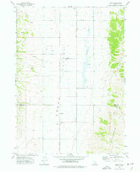
1973 Map of Arbon
USGS Topo · Published 1977About this map
Arbon Valley serves as the primary corridor for agricultural activity and settlement in this portion of southeastern Idaho. The map captures the quiet rural character of the region during the early 1970s, centered around the Arbon PO and the nearby Arbon settlement. These small hubs, alongside the Arbon Cem, provide essential anchor points for genealogical research and local history in a landscape otherwise defined by broad valleys and rising heights. To the east, the Pleasantview Hills rise above the drainage of Bannock Creek, where numerous Springs emerge from the terrain. Evidence of the mid-century aviation and resource economy is visible through the presence of an Airway Beacon on a high ridge and a local Gravel Pit. The map also delineates the jurisdictional boundary between Power County and Oneida County, showing how these borders intersect the grazing lands and valley floors.
Find a feature on this map
15 named features on this map. Tap any name to fly to it.
Don’t see what you’re looking for? This feature index may not catch every label — zoom into the map to look around manually.
Map Details
Editions of this 1973 Arbon Map
This is the sole edition of this map. No revisions or reprints were ever made.
Other maps of this area

1938 · Pauline
USGS Topo · 1:48,000

1944 · Arbon
USGS Topo · 1:62,500

1954 · Pocatello
USGS Topo · 1:250,000

1958 · Pocatello
USGS Topo · 1:250,000

1963 · Daniels
USGS Topo · 1:24,000

1968 · Daniels
USGS Topo · 1:24,000

1968 · Dairy Creek
USGS Topo · 1:24,000

1968 · Bradley Mtn
USGS Topo · 1:24,000

1971 · Bannock Peak
USGS Topo · 1:24,000
1971 · Pauline
USGS Topo · 1:24,000