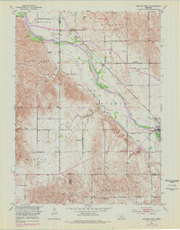
1951 Map of Arcadia West
USGS Topo · Published 1978About this map
Arcadia sits at the eastern edge of this landscape, where the Burlington Northern railroad tracks follow the corridor of the Middle Loup River. This 1951 survey, with later 1974 revisions, captures the agrarian rhythm of Valley County, where a complex network of irrigation channels like Canal No 3 and the Feeder Canal support the surrounding farms. The map is particularly rich in rural educational infrastructure, documenting numerous one-room schools scattered across the townships of Liberty, Spring Creek, and Washington. Local history researchers will find several named institutions, including Ohme Sch, Rosebud Sch, and Knight Sch. Family history is further anchored by the presence of Sacred Heart Cem and Lee Park Cem, located within the Myrtle and Park districts, providing a detailed record of the community's mid-century footprint.
Find a feature on this map
29 named features on this map. Tap any name to fly to it.
Don’t see what you’re looking for? This feature index may not catch every label — zoom into the map to look around manually.
Map Details
Editions of this 1951 Arcadia West Map
3 editions found
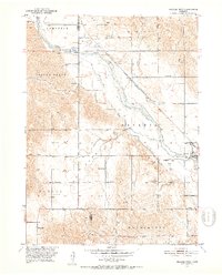
Other maps of this area

1951 · Ansley NE
USGS Topo · 1:24,000

1951 · Arcadia SE
USGS Topo · 1:24,000

1951 · Arcadia West
USGS Topo · 1:24,000

1951 · Arcadia East
USGS Topo · 1:24,000

1951 · Ansley SE
USGS Topo · 1:24,000

1951 · Arcadia SW
USGS Topo · 1:24,000

1952 · Sargent SE
USGS Topo · 1:24,000

1952 · Comstock
USGS Topo · 1:24,000

1952 · Comstock SE
USGS Topo · 1:24,000

1955 · Broken Bow
USGS Topo · 1:250,000