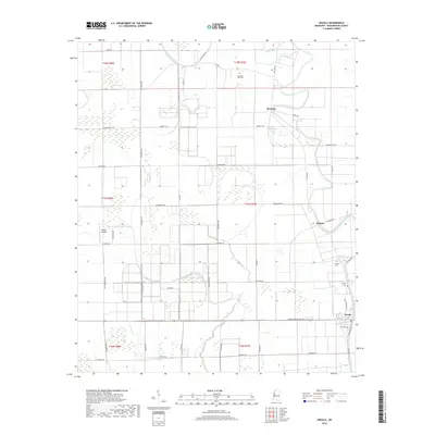
2018 Map of Arcola
USGS Topo · Published 2018About this map
Arcola and its surrounding delta flatlands are defined by a complex network of waterways and agricultural drainage in this 2018 survey. The landscape is dominated by the meandering course of Deer Creek to the east and the winding Swiftwater Bayou through the center, illustrating the hydraulic character of Washington County. Small settlements like Burdette and Wilmont are connected by a grid of rural roads, many bearing family names such as Billy Greenway Rd, Hendrix Rd, and Douglas Rd, which reflect the local history of land ownership and farming. For genealogists and local researchers, the map identifies several distinct burial sites including Morning Star Cem, Paxton Cem, and Arcola Cem. The presence of the Abide Airpark and the legacy route of Old Hwy 61 further detail the transportation evolution of this Mississippi Delta region.
Find a feature on this map
53 named features on this map. Tap any name to fly to it.
Don’t see what you’re looking for? This feature index may not catch every label — zoom into the map to look around manually.
Map Details
Editions of this 2018 Arcola Map
This is the sole edition of this map. No revisions or reprints were ever made.
Other maps of this area

1939 · Readland
USGS Topo · 1:62,500

1939 · Refuge
USGS Topo · 1:62,500

1939 · Tralake
USGS Topo · 1:62,500

1939 · Swan Lake
USGS Topo · 1:62,500

1953 · Greenwood
USGS Topo · 1:250,000

1956 · Greenwood
USGS Topo · 1:250,000
1967 · Tribbett
USGS Topo · 1:24,000

1967 · Arcola
USGS Topo · 1:24,000

1967 · Leland
USGS Topo · 1:24,000
1967 · Holly Ridge
USGS Topo · 1:24,000