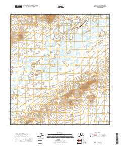
2018 Map of Arctic A-3 SW
USGS Topo · Published 2018About this map
The East Fork Chandalar River winds through this interior Alaskan landscape, defining a network of wetlands and tundra lakes. Near the northeastern corner, the Arctic Village Airport serves as a critical transport hub, connected to the nearby settlement area by local routes including Airport Street, Lee Street, and Mountain Street. The terrain shifts from the low-lying basin of the Chandalar to the significant rise of Marten Stand Mtn in the southeast, providing a clear view of the transition from riparian zones to higher elevations.
Find a feature on this map
20 named features on this map. Tap any name to fly to it.
Don’t see what you’re looking for? This feature index may not catch every label — zoom into the map to look around manually.
Map Details
Editions of this 2018 Arctic A-3 SW Map
This is the sole edition of this map. No revisions or reprints were ever made.
Other maps of this area

1951 · Christian
USGS Topo · 1:250,000

1951 · Arctic
USGS Topo · 1:250,000

1956 · Arctic
USGS Topo · 1:250,000

1956 · Christian
USGS Topo · 1:250,000

1972 · Arctic A-3
USGS Topo · 1:63,360
1972 · Arctic A-4
USGS Topo · 1:63,360
1972 · Christian D-3
USGS Topo · 1:63,360
1990 · Christian D-4
USGS Topo · 1:63,360
2018 · Arctic A-3 SE
USGS Topo · 1:25,000
2018 · Arctic A-4 NE
USGS Topo · 1:25,000