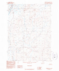
1990 Map of Christian D-4
USGS Topo · Published 1990About this map
Arctic National Wildlife Refuge lands dominate the northwestern corner of this 1990 survey, where the Chandalar River, East Fork flows through a landscape defined by dramatic relief and elevation markers. This provisional map, compiled from 1971 aerial photography, captures a territory without established roads or trails, illustrating the high-altitude interior of the northern Alaskan wilderness. The North Boundary Fairbanks Meridian bisects the upper portion of the sheet, providing a primary surveying baseline for this remote region. Throughout the quadrangle, dozens of water levels and spot elevations are recorded, documenting a terrain of peaks and drainage systems as they were understood during the late twentieth-century mapping of the Arctic interior.
Find a feature on this map
4 named features on this map. Tap any name to fly to it.
Don’t see what you’re looking for? This feature index may not catch every label — zoom into the map to look around manually.
Map Details
Editions of this 1990 Christian D-4 Map
This is the sole edition of this map. No revisions or reprints were ever made.
Other maps of this area

1951 · Christian
USGS Topo · 1:250,000

1951 · Arctic
USGS Topo · 1:250,000

1956 · Arctic
USGS Topo · 1:250,000

1956 · Christian
USGS Topo · 1:250,000

1972 · Arctic A-3
USGS Topo · 1:63,360
1972 · Arctic A-4
USGS Topo · 1:63,360
1972 · Christian D-3
USGS Topo · 1:63,360
1972 · Christian C-3
USGS Topo · 1:63,360
1983 · Christian C-3
USGS Topo · 1:63,360
1990 · Christian C-4
USGS Topo · 1:63,360