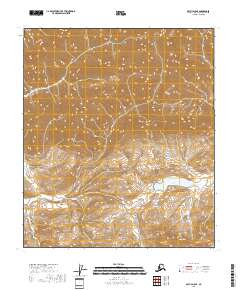
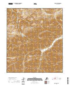
2018 Map of Arctic D-5 SE
USGS Topo · Published 2018About this map
Mt Annette rises as the dominant topographical feature in this high-latitude terrain of the Alaska North Slope, providing a stark orientation point for the surrounding wilderness. The landscape is defined by the significant basin of Porcupine Lake, which sits at the heart of an intricate network of drainage and elevation contours. This 2018 survey illustrates a remote portion of the Brooks Range where human infrastructure is entirely absent, replaced by a complex system of ridges and valleys that dictate the natural flow of the region. The map captures the specialized topography of the Arctic, including the precise boundaries of Township and Range divisions such as t7s r24e and t8s r24e, marking out the land for federal administrative purposes in a territory otherwise untouched by roads or permanent settlements.
Find a feature on this map
8 named features on this map. Tap any name to fly to it.
Don’t see what you’re looking for? This feature index may not catch every label — zoom into the map to look around manually.
Map Details
Editions of this 2018 Arctic D-5 SE Map
This is the sole edition of this map. No revisions or reprints were ever made.
Other maps of this area

1951 · Arctic
USGS Topo · 1:250,000

1956 · Arctic
USGS Topo · 1:250,000
1971 · Arctic D-5
USGS Topo · 1:63,360
1971 · Arctic C-5
USGS Topo · 1:63,360
1983 · Arctic D-4
USGS Topo · 1:63,360
1983 · Arctic C-4
USGS Topo · 1:63,360
2018 · Arctic C-4 NW
USGS Topo · 1:25,000
2018 · Arctic D-4 NW
USGS Topo · 1:25,000
2018 · Arctic D-4 SW
USGS Topo · 1:25,000
2018 · Arctic C-5 NE
USGS Topo · 1:25,000