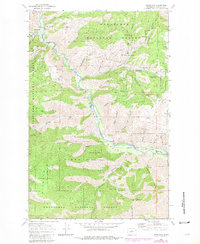
1968 Map of Ardenvoir
USGS Topo · Published 1981About this map
The settlement of Ardenvoir serves as the focal point of this 1968 study, situated along the banks of the Entiat River as it flows through the Entiat Valley. The landscape is defined by the steep topography of the Wenatchee National Forest, where numerous drainages like Crum Canyon and Dinkelman Canyon feed into the river system. Man-made infrastructure is interwoven with the natural terrain, notably the Entiat Ditch and a Fish Hatchery, indicating the importance of water management and local industry in this part of Chelan County.
Find a feature on this map
36 named features on this map. Tap any name to fly to it.
Don’t see what you’re looking for? This feature index may not catch every label — zoom into the map to look around manually.
Map Details
Editions of this 1968 Ardenvoir Map
3 editions found
Other maps of this area

1901 · Chelan
USGS Topo · 1:125,000

1957 · Wenatchee
USGS Topo · 1:250,000

1968 · Orondo
USGS Topo · 1:24,000

1968 · Entiat
USGS Topo · 1:24,000
1968 · Cashmere
USGS Topo · 1:24,000

1968 · Tyee Mtn.
USGS Topo · 1:24,000

1968 · Ardenvoir
USGS Topo · 1:24,000

1968 · Baldy Mtn
USGS Topo · 1:24,000
1968 · Chumstick Mtn
USGS Topo · 1:24,000

1968 · Winesap
USGS Topo · 1:24,000