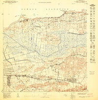
1950 Map of Arecibo NE
USGS Topo · Published 1950About this map
The expansive Cénaga de Tiburones dominates this coastal landscape just east of the Arecibo city center, revealing a mid-century environment defined by wetlands and sugar-growing districts. Land use patterns follow the various barrios, including Santana, Islote, and Domingo Ruiz, where small settlements like Poblado Santana and Garrochales are concentrated along the main thoroughfares. Along the northern edge, the Océano Atlántico coastline is marked by distinct promontories such as Pta Caracoles and Pta Las Tunas, providing a natural boundary to the agricultural and transit-oriented interior. The presence of the Arecibo Airport and the Antenas de Radio (WKVN) signals the modern infrastructure development of the late 1940s, while the older R R (railroad) and Porto Rico road system continue to support the local economy. Water management is evident through features like the Zanja Desvío Valdez and Charco La Tembladera, illustrating how the marshy terrain was navigated and utilized.
Find a feature on this map
31 named features on this map. Tap any name to fly to it.
Don’t see what you’re looking for? This feature index may not catch every label — zoom into the map to look around manually.
Map Details
Editions of this 1950 Arecibo NE Map
This is the sole edition of this map. No revisions or reprints were ever made.
Other maps of this area

1942 · Arecibo
USGS Topo · 1:30,000

1942 · Barceloneta
USGS Topo · 1:30,000

1946 · Barceloneta
USGS Topo · 1:30,000

1946 · Arecibo
USGS Topo · 1:30,000
1947 · Barceloneta SO
USGS Topo · 1:10,000
1947 · Arecibo SO
USGS Topo · 1:10,000
1947 · Arecibo SE
USGS Topo · 1:10,000
1950 · Arecibo NO
USGS Topo · 1:10,000
1953 · Arecibo
USGS Topo · 1:30,000
1953 · Barceloneta
USGS Topo · 1:30,000
Featured Places
- Reparto Capitolio, Arecibo
- Reparto Los Maestros, Arecibo
- Arecibo
- Estancias de Arecibo, Arecibo
- Urb. Los Pinos I, Arecibo