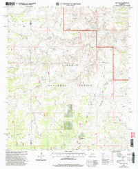
2001 Map of Ares Peak
USGS Topo · Published 2003About this map
Lincoln National Forest encompasses the majority of this high-desert landscape at the boundary of Otero and Eddy counties. The terrain is defined by a dense network of drainages including North Rocky Arroyo, Middle Rocky Arroyo, and Pierce Canyon, all feeding toward the regional watershed system. Prominent elevations such as Ares Peak and Texas Hill overlook a series of ridge-lines and canyons that have historically supported ranching operations.
Find a feature on this map
25 named features on this map. Tap any name to fly to it.
Don’t see what you’re looking for? This feature index may not catch every label — zoom into the map to look around manually.
Map Details
Editions of this 2001 Ares Peak Map
This is the sole edition of this map. No revisions or reprints were ever made.
Other maps of this area

1935 · El Paso Gap
USGS Topo · 1:62,500

1936 · El Paso Gap
USGS Topo · 1:48,000

1940 · El Paso Gap
USGS Topo · 1:62,500

1940 · Bandanna Point
USGS Topo · 1:62,500

1940 · Carlsbad Caverns West
USGS Topo · 1:62,500

1943 · Carlsbad Caverns West
USGS Topo · 1:62,500

1943 · Bandanna Point
USGS Topo · 1:62,500

1943 · Texas Hill
USGS Topo · 1:62,500

1945 · Texas Hill
USGS Topo · 1:62,500

1954 · Carlsbad
USGS Topo · 1:250,000