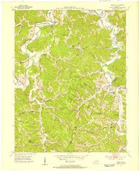
1953 Map of Argillite
USGS Topo · Published 1955About this map
The Little Sandy River carves a winding path through this corner of Greenup County, defining a landscape of hollows and ridges where early industry and education left their marks. At the crossroads of Argillite, the Argillite Fire Tower stands as a sentinel over the valley, while the presence of an Iron Furnace near Hunnewell points to the region's historical mineral exploitation. The transition from timber and iron to coal is visible in the numerous Strip Mines appearing in the southern reaches toward the Boyd County line.
Find a feature on this map
71 named features on this map. Tap any name to fly to it.
Don’t see what you’re looking for? This feature index may not catch every label — zoom into the map to look around manually.
Map Details
Editions of this 1953 Argillite Map
This is the sole edition of this map. No revisions or reprints were ever made.
Other maps of this area

1898 · Ironton
USGS Topo · 1:62,500

1900 · Ironton
USGS Topo · 1:62,500

1901 · Ceredo
USGS Topo · 1:62,500

1903 · Kenova
USGS Topo · 1:125,000

1904 · Kenova
USGS Topo · 1:125,000

1913 · Ceredo
USGS Topo · 1:62,500

1926 · Greenup
USGS Topo · 1:48,000

1930 · Greenup
USGS Topo · 1:62,500

1953 · Grayson
USGS Topo · 1:24,000

1953 · Oldtown
USGS Topo · 1:24,000