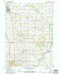
1962 Map of Argos
USGS Topo · Published 1994About this map
The Tippecanoe River meanders across the southeastern corner of this northern Indiana landscape, where the Old Indian Treaty Boundary still marks the land divisions between Walnut and Richland townships. The town of Argos serves as the primary hub in the northwest, situated along the Nickel Plate Road. This survey, field-checked in the early 1960s and later updated, captures a rural transition as family farms and scattered schoolhouses defined the community structure between Marshall and Fulton counties.
Find a feature on this map
46 named features on this map. Tap any name to fly to it.
Don’t see what you’re looking for? This feature index may not catch every label — zoom into the map to look around manually.
Map Details
Editions of this 1962 Argos Map
Other maps of this area

1953 · Chicago
USGS Topo · 1:250,000

1957 · Chicago
USGS Topo · 1:250,000

1957 · Inwood
USGS Topo · 1:24,000

1957 · Plymouth
USGS Topo · 1:24,000

1958 · Bourbon
USGS Topo · 1:24,000

1959 · Mentone
USGS Topo · 1:24,000

1962 · Pershing
USGS Topo · 1:24,000
1962 · Akron
USGS Topo · 1:24,000

1962 · Argos
USGS Topo · 1:24,000
1962 · Rochester
USGS Topo · 1:24,000