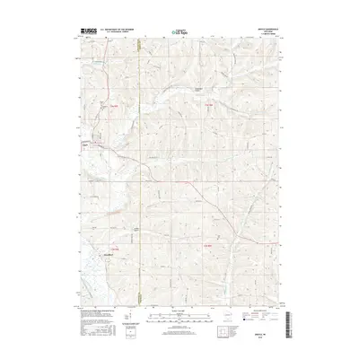
2016 Map of Argyle
USGS Topo · Published 2016About this map
The E Br Pecatonica River winds through the driftless-style topography of southern Wisconsin, serving as the central geographic feature for the village of Argyle and the community of Woodford. This map documents a landscape defined by deeply incised valleys and drainage networks, including Dougherty Cr and Jordan Cr. The settlement pattern reflects the area's agricultural roots, with numerous rural roads like Puddledock Rd and Duncan Hill Rd following the contours of the high ridges and hollows. Local heritage is preserved in sites such as Woodlawn Cem and Calvary Cem near the Argyle village limits, as well as the secluded Lewis Cem further south. Distinctive named terrain features like Puddledock Hollow and Jockey Hollow illustrate the complex watershed that feeds into the river system.
Find a feature on this map
64 named features on this map. Tap any name to fly to it.
Don’t see what you’re looking for? This feature index may not catch every label — zoom into the map to look around manually.
Map Details
Editions of this 2016 Argyle Map
This is the sole edition of this map. No revisions or reprints were ever made.
Other maps of this area

1920 · Monroe
USGS Topo · 1:62,500

1922 · Monroe
USGS Topo · 1:62,500

1923 · Blanchardville
USGS Topo · 1:62,500

1923 · New Glarus
USGS Topo · 1:62,500

1923 · South Wayne
USGS Topo · 1:62,500

1954 · Rockford
USGS Topo · 1:250,000

1955 · Rockford
USGS Topo · 1:250,000

1958 · Rockford
USGS Topo · 1:250,000
1962 · New Glarus
USGS Topo · 1:62,500
1962 · Monroe NW
USGS Topo · 1:24,000