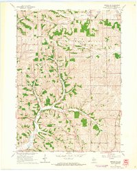
1962 Map of Monroe NW
USGS Topo · Published 1964About this map
The rural landscape of northwestern Monroe and southern Washington townships is defined by the headwaters of the South Branch Hefty Creek and Bushnell Creek in the early 1960s. This agricultural region of Green County is dotted with the remnants of 19th-century social infrastructure, including several country schools like Blackford Sch and Argus Sch that served the surrounding farmstead families. Of particular note for genealogists are the family-named burial grounds and houses of worship, such as the Washington Ch and the Benkert-Bushnell Cem, which anchor the local community history. The terrain transitions into Shocks Prairie in the south, where numerous small quarries suggest a history of local stone extraction for building and road construction. The presence of the Iliff Cem and Iliff Sch near the southern border highlights how certain family names became synonymous with specific corners of the township.
Find a feature on this map
22 named features on this map. Tap any name to fly to it.
Don’t see what you’re looking for? This feature index may not catch every label — zoom into the map to look around manually.
Map Details
Editions of this 1962 Monroe NW Map
2 editions found
Other maps of this area

1920 · Monroe
USGS Topo · 1:62,500

1922 · Monroe
USGS Topo · 1:62,500

1923 · Blanchardville
USGS Topo · 1:62,500

1923 · New Glarus
USGS Topo · 1:62,500

1923 · South Wayne
USGS Topo · 1:62,500

1954 · Rockford
USGS Topo · 1:250,000

1955 · Rockford
USGS Topo · 1:250,000

1958 · Rockford
USGS Topo · 1:250,000
1962 · Juda
USGS Topo · 1:24,000
1962 · New Glarus
USGS Topo · 1:62,500