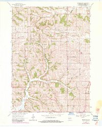
1962 Map of Monroe NW
USGS Topo · Published 1983About this map
Shooks Prairie and the surrounding farmland of Green County define this landscape as it appeared in the early 1960s. The area is characterized by a dense network of local landmarks, reflecting a well-established rural community organized around the townships of Adams, Washington, Jordan, and Monroe. Numerous small educational centers, including Buckskin School, Argus School, and Blackford Sch, are scattered across the terrain, indicating the importance of neighborhood-based schooling before the era of widespread consolidation.
Find a feature on this map
26 named features on this map. Tap any name to fly to it.
Don’t see what you’re looking for? This feature index may not catch every label — zoom into the map to look around manually.
Map Details
Editions of this 1962 Monroe NW Map
2 editions found
Other maps of this area

1920 · Monroe
USGS Topo · 1:62,500

1922 · Monroe
USGS Topo · 1:62,500

1923 · Blanchardville
USGS Topo · 1:62,500

1923 · New Glarus
USGS Topo · 1:62,500

1923 · South Wayne
USGS Topo · 1:62,500

1954 · Rockford
USGS Topo · 1:250,000

1955 · Rockford
USGS Topo · 1:250,000

1958 · Rockford
USGS Topo · 1:250,000
1962 · Juda
USGS Topo · 1:24,000
1962 · New Glarus
USGS Topo · 1:62,500