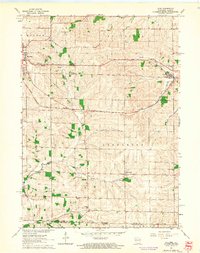
1962 Map of Juda
USGS Topo · Published 1964About this map
The agrarian borderlands of southern Green and Stephenson Counties are captured here in the early 1960s, showing the precise intersection of the Wisconsin-Illinois state line. The village of Juda serves as a local hub along the Chicago Milwaukee St Paul and Pacific railroad, while the eastern outskirts of Monroe show modern infrastructure in development, notably the Monroe Municipal Airport which was noted as under construction at the time of the survey. The landscape is defined by the winding course of Richland Creek and its tributaries, including the Twin Grove Branch. This era of rural education is well-preserved on the map, documenting localized district schools such as Ball School, Richland School, and Pleasant Grove School, many of which were central to the small farming communities like Twin Grove and East Clarno.
Find a feature on this map
27 named features on this map. Tap any name to fly to it.
Don’t see what you’re looking for? This feature index may not catch every label — zoom into the map to look around manually.
Map Details
Editions of this 1962 Juda Map
3 editions found
Other maps of this area

1893 · Brodhead
USGS Topo · 1:62,500

1920 · Monroe
USGS Topo · 1:62,500

1922 · Monroe
USGS Topo · 1:62,500

1932 · Pecatonica
USGS Topo · 1:62,500

1936 · Pecatonica
USGS Topo · 1:62,500

1939 · Freeport
USGS Topo · 1:48,000

1944 · Freeport
USGS Topo · 1:62,500

1954 · Rockford
USGS Topo · 1:250,000

1955 · Rockford
USGS Topo · 1:250,000

1958 · Rockford
USGS Topo · 1:250,000